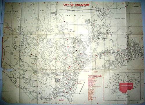
Below are the oldest copies of the Singapore Street Directory I have in my house…until what I have found at my mother’s house at Haig Road on last Sunday. Ha I believed Peter and Chun See may even have older copies than this since they are at least 10yrs my senior. Frankly buying the Singapore Street Directory is like buying First Day Covers issues, every now and then new edition come out due to more new roads being built.

Credit : Singapore Government, Chief SurveyorOn the left is the Chinese Edition (1976) which is based on the English Edition (1975) and on the right is the English Edition (1988).
Now I have another even older map of Singapore from the Shell. The year 1959 was written on the inside cover of the map;

Credits for all the Shell Map Reproduction: Shell, Singapore Government Survey Department.
So this map was prepared by SIT (Singapore Improvement Trust, which is the ‘ancestor’ of HDB) in 1956;

Let’s take a look at this old map;
Only this part of Singapore was reproduced in the map;

Below are some of the Places Of Interests in the 50s where a number of them were no longer around now;

Now let’s take a close up view of this old map and see what’s in 50s;

You can see the Singapore Airport at the Paya Lebar from the above map, but has it been completed then? Guess… Of course all the expressways like PIE, ECP, etc.. were not built then. Also Singapore size then was much smaller before the major land reclamation from 60s to 90s.


Hey, you should consider contributing your old 1959 Shell map to the National Library’s heritage show – they have it every year in the 3rd quarter, I think. If you cannot donate it, they can scan it and will return the original copy to you.
Wow, those maps are so amazing. I agree you should consider contributing one of them… I wonder where one can buy old street directories now though. Probably very expensive.
Even just 15 years ago the street directory shows such different things from now; like a whole load more of lorongs and kampongs as well as Sengkang being undeveloped… and the old Bukit Timah-Jurong railway line etc. A lot of your average uncles and aunties in Singapore have witnessed great amounts of change but only few are talking about it on the blogosphere I think.
Sob! Sob! My dad had the 1988 Street Directory last year.
But, my younger brother threw it away! He said, “Why keep? Outdated already.”
The latest copy we had now is in 1998. 😦
I need it to compare the past and present maps to show the changes on this portal myhometown.sg
Do you or someone else have another copy of 1988 Street Directory?
Wow! I’m amazed at all the old photos and knickknacks you have. Now I’m looking for a photo of the esplanade area before the Esplanade – Theatres on the Bay was built, for my Geography assignment by this weekend. I have searched many hours over the past few days but all fruitless. Can anyone help me, please?
I too wish I had kept some of the old maps. My oldest one is 1993 but most of the old places I am interested in are no longer there.
Morningglory. You can see pictures of Esplanade at Memories of Singapore”.
Sorry that should be: http://www.singas.co.uk/HTML/singapore_in_the_sixties_3.html
Morning glory
I got a couple dating back to the 1950s when they had the first hawker center built in 1958 which later became the Satay Club (when they moved over from Beach Road). if you want those up to Nicoll Highway (near the collapse of the tunnel) I also can share with you. It was also called the Esplanade – for courting couples. Just send your email addr to Laokokok
Morning Glory
I just checked – I have some taken in 1972 and 1985 (where I think The Esplanade Theaters are now). The crescent-shaped hawker center (built by the british Colonial GOvt) was facing those theaters was demolished to build the Satay Club in the mid-1970s.
Maybe u write your email addrr here and I can send to you.
Thanks a great deal, Lam Chun See and profkingsfield2004. You guys really save my day (and night too). The photos in the website given by Lam Chun See should be good enough for now. Thanks again. Didn’t expect to I could get response so fast.
I just love this blog. Will explore it more when I have more time.
Hi Victor and Passerby,
Thanks for the suggestion and points noted. Let me consolidate more at my mother’s house first as she has more ‘artifacts’ than me haha.
Hi Hyacinthus,
You may try those old bookshop at Bras Basah. I saw some in one of them (very good condition though), but the price…
Thanks Chun See and Peter – for helping Morningglory in his project.
Wow, the 1956 city map is a real treasure. And my dad used to have the 1988 street directory that you highlighted. Alas, like many old things in the house, it has been thrown away.
Always amazed at the amount of things you have held on to. Thank goodness that you have!
Hi Acroamatic,
I too thrown away a lot of things when I was younger. Only after I started to age, I then collect all these stuffs like my mom hehe….
Yes, unfortunately that’s a realisation that many of us hit upon too late. I’ve mentioned elsewhere that I threw away my MRT commemorative ticket for the opening day. *sigh* It’s not like it was taking a lot of space. I also stupidly threw away my only primary school annual.
The worst thing that we could throw away is our memory. Once is gone, is gone.
whooo i remember finding the 1988 street directory when i was searching for one! haha, i think we only just recently bought a new one when the whole family suddenly realised that we don’t have the most updated copy of it..
i think it’s still sitting around my house somewhere. funny to think that it’s one year older than me 😛
Hi
Love the site – brings back a lot of memories!
My father was in the RAF and we lived in Changi in 1964/5 – I’m writing a novel based on my childhood and am trying to track down where we lived (unfortunately both my parents died in 1991).
I know it was away from the RAF camp and we lived opposite the jungle which had a kampong in it. Just over the road and in front of the jungle area there was a field of oxen. There was a small swamp at the end of the road and we were near a cemetery (not a christian cemetery)
I believe it was in the Siglap/Bedok area and thanks to Google Earth had worked out that it may have been Swan Lake Road in the Opera Estate as there used to be a kampong there and there is a cemetery next to the Flamingo condominium. But I remember mum and us kids walking to the ahma’s night market and have worked out that we walked along the Bedok canal, which seems to be a long way from Swan Lake Road?
Any ideas?
Cheers
Des
Des
Can u remember whether that was a Chinese (at Simpang Bedok) or Malay cemetery. The Malay cemeteries are at Siglap Road, Kew Drive and Kg Bedok (around Bedok Corner). The swamps you mentioned were at Koh Sek Lim Road just next to the S. Bedok (now Bedok Canal) or the present Tanah Merah MRT Station area. Your family probably rented a local sem-D house.
U need to establish whether the cemetery was on flat ground or on hilly ground. I am familiar with Siglap area of the 1960s. U drop Laokokok your email and we can get in contact.
Ah Mah’s Nite Market was at Bedok Corner – the present-day Bedok Corner hawker Center
Your house was probably at Jalan Pari Dedap next to the present-day Anglican High School. Opposite Jalan Pari Dedap was a Chinese cemetery which is now Tanah Merah Kechil Avenue. You could not have stayed at Jalan Chempaka Kunning because those semi-Ds were built in the late 1968.
Hi there,
I was going through the net…looking for the old maps and street directories of singapore..(1960 – 1980), when I came across your website. It’s a very cool website and brings back lots of memories…smile.
Actually, I was trying to find old maps and street directories of the KTMB branch lines…meaning during the early years, KTMB (Malayan Railway) railway got branch lines going to other places of singapore, other than the mainline to JB. ie: old bukit timah railway station – jurong port line. old brickworks line – near to alexandra road
That was where i came across your website. I really miss those days where i used to stay at bukit merah and notice the railway line beside the former OG and near Safra.
I would really appreciate it if you could let me know how I can get a copy of these directories..or maybe a scan of these railway lines if it is not too troubling you…as i would like to track back those lines…if they are still available…smile.
thanks and regards
silvermusang
silvermusang – i keep track of old KTM railway tracks u need. If u drop me your email, then we can get started.
If u are interested to know, the present-day Cantonment Link was the site of the first railway track running from Tg Pagar thru Chinatown to Tank Road in the early 20th century i.e. 1900s.
Hi silvermusang,
You can email me so that I can give your email to Peter (profkingsfield2004).
Hi Den2,
It’s good to start keep the old street directory.
Hi Des,
Thanks for visiting this blog. I think Peter will be able to help you. I’ve sent your email to him.
Looking closely at the map, I can see that the area that I am interested in – Pasir Panjang – is slightly damaged. There is a hole and the edge is slightly frayed. Is there an Island View Road (currently it is Kent Ridge Crescent) that connects to Kent Ridge Road?
Is it shown in the 1976 road directory? I’d appreciate it a lot if you can check this for me. Would love to add more detail to this post.
Hi Kenneth (acroamatic),
I’ve emailed to you some copies of the maps on Island View Road (Check yr email). The old city map is damaged so the portion you required may not show up. I’ve checked the 70s street directory and it’s still there. But the 80s one, already changed to Kent Ridge Crescent.
Thanks, laokokok! It hasn’t arrived in my email yet, I’ll check again later in the day.
Whoops! Your email ended up in my spam box. Thanks you so much for the maps!
Where did you get the 1959 shell map from ? I had to buy mine from a bookstore overseas. And it it’s in even worse condition than yours.
Incidentally, does anyone know of a good restorer or framer who could paste up the torn map onto a board or find some other way to preserve it ?
HI Shih Tung,
I got this map from my mum. Probably they bought it many many years back. In fact, most of Singapore old postcards are available in other countries – as far as France…
hey.
would you be able to scan a 1959 sg map to me?
cause i need it fr my geog project =D
we need to research abt sg’s land reclamation.
thx alot!
Hi, I remember old Singapore Street Directory had a short write up of the road if it is named after a prominent person. Can you do me a favour to check on Joo Chiat Road? I would like to see the article.
Thanks.
Hi Philip,
My old street directories do not have such write up of the road. Joo Chiat one is quite common and easily Google it. There is a book in the library (can’t remember the name of book) has all the road names in Singapore – with all the write ups. Very good book to do reference.
Hi Philip,
I have just emailed you a list of toponymics books on Singapore.
I am a student reading some modules on the history of urban planning in singapore, I would appreciate if I can have a copy of your detailed road maps, preferably around pasir panjang area or anywhere south.
Sorry if this is too abrupt.
Hello,
A great site that brings back lots of memories…
Just curious: do you still have the old Singapore street directory? I am looking for a page that conatins “Block 44 Dakota Crescent”. That’s my old kampung. I would appreciate it if you could send me a scanned page.
Many thanks!
Ben
I was doing a google search for “Old Singapore Street Directory” when I stumbled upon this blog. What a fantastic blog this is. Thank you Laokokok for this blog. I kinda like to collect old books about Singapore too.
Ben…you mentioned Block 44, Dakota Crescent. Is this the 1-roomed flats?
Hi Hamzah,
No. Blk 44 was a block of 3-room flats. The few blocks there had been demolished.
Anyway, i found the map from the National Library.
Have a nice day!
Ben
Ben..thanks for the info. I just remembered those 1-roomers were Blocks 60 something). I was then staying at Block 4 (an old SIT 2-room rental flats) Dakota Crescent before moving to Bedok in 1979. I still have some friends staying in Old Airport. So we were in the same kampung after all. How time flies.
I have a copy, near mint condition of the Singapore Road Directory 1981 edition. That is the oldest.
I have a map of Malaya printed in the early 1900’s showing Perlis, Kedah, mcuh of Kelantan and Trengganu as part of Siam.
I have even older ones which I collect for fun. I love maps.
I have recently hand drawn from my memory a map of the Chin Swee Road Cornwall strreet and Pulau Saigon Circus. Park Road area in the 1950s/1960s, including landmarks and buildings I remembered. I was born there and live there until I was 16 before we move out of there.
To Mark T – I think my copy that I have “SINGAPORE Guide & Street Directory”, published my the Ministry of Culture in March, 1969 is still the oldest….Has anyone else got the earliest edition printed in 1954??? The newer edition are now titled “Singapore Street Directory”.
I’m impressed Mark!
I haven’t been in Singapore since the early 70’s and I’m returning to look around whilst on holidays and I’m having difficulties in getting a map that looks any thing like what remember , the Chom Pang and Sembawang area maps of today don’t seem to be any thing like I remember
Hi Craig,
Welcome back to Singapore. If you still wish to have a copy of the old Singapore map or directory, you may try those 2nd bookshop at the Bras Basah Complex. But they do not come cheap too.
Hi Ben,
Been reading this site since I came across it doing some search for old photos. Came across your comment. I once lived in Dakota Cresent Block 64.
You’ve photos of that area?. Pity it was demolished.A friendly estate where all doors are always open to neighbours and during the racial riot, the residents came together to guard the area thro 1 open entrance and locking up the other fence doors (that time the entrances to such 3-storey flat had fence door at all entrances).
Ahh..those were the days of spiders and “catch” kites.
Hi
I have been trying to trace where I lived in Singapore in 1966, and some of you following this thread have been a great help! I have (almost) confirmed that I lived at Jalan Terang Bulan on the Opera Estate.
Can anyone direct me to a 50s/60’s map of that area as I would like to track down a nearby cemetery and Kampong. I live in Canada so it would need to be on-line or scanned.
Also any memories or photographs of the area would be greatly appreciated!
Thanks
Denise
Hi Denise!
I know Jalan Terang Bulan but a little after you lived there. I have cousins who still live there. As a child I remember fearfully bicycling down that steep road which led down to Opera Estate. I remember it being a very nice and quiet area. I stand corrected but I recall a big canal drain too along Jalan Terang Bulan or somewhere in the vicinity. I recall a little cemetary at the entrance of a small Kampong but it was alongside a busy road that led to the Opera Estate.I’ve forgotten its name.
I have’nt been back to S’pore in over 20 years. You mentioning Jalan Terang Bulan suddenly brought back a flood of memories to me.I had a nice little walk down memory lane.I do a lot of that here on this blog.
This is a great blog of Laokokok and I’m sure there are competent people here who’ll be glad to help you.
Jean.
wow wonderful.im keen on the map of old bukit panjang,roads like jalan cheng hwa,lorong petir,jalan senja,can scan n email to me at the above mention email
Wow it’ll be great if you can pass me those old maps in high resolution! interesting to check it out
Hi, thank so much for your blog. It has helped me alot in doing my assignment!
Biggest thank.
And, is it ok for you to send me some pictures/maps in high resolution?
Thanks anw!
Hi everyone,
I’m doing post-graduate studies at Bauhaus Kolleg in Germany. We are looking at Queenstown as a housing development, and my individual research topic is car dependency, mobility, and public transportation and how these factors shaped urban planning process in Queenstown in the past 50 years. I’m trying to find old road, street maps, public transportation maps, but not very succesfull so far. Can anyone help me on this issue? this research at the end of the year might get published, and I will credit anyone who would help in that publication. Thank you very much.
Check this old photo:
But you will not see the HDB block.
Hi Ben,
Thanks for the link to the old photo. Really difficult to tell the place from that old photo.
Hi
Came to your site. Great. Can you check the Singapore General Hospital site maps to see if an old site marking the shrine of Baba Karam Singh ( near the Hospital University Site is listed.) It was not on any of the old directories I got my hands on. I need research on it.
Thanks.
enjoyed reading your blog.
i was wondering if your old maps showed 3 1/4ms mon hock road / thomson village?
i am trying to locate where this area is. thanks.
Thank you KK.
stumbled on this blog and saw hamzah comments about dakota crescent. the 1-room flats are blk 58,60,62,64 and 66 near the river. at that time around 1972, broadrick secondary school and maju sec school were located there opp the 1SIR army camp. you can get to katong by walking along the river and take a short-cut to crescent road.
Yes OngKK, I still remember that 2 schs Broadrick and Maju. Wonder if these 2 schs still exists?
there are also two primary schools next to the then VITB. one Mountbatten English School and the other Mountbatten Government Chinese Pri Sch. I attended the MES from 1966 -1971.
hello can u send me the picture of queensway area because i am working on a project about that area?=D
hi laokokok,
i am a architectural student doing my dissertation project on Bugis Street. was searching for old maps of singapore and i stumbled upon up blog! its really amazing to know that you do have the old maps of 1959, 1976 and 1988. I m looking into the history of the street and how it did transformed over the years, and so happened that these years are the significant years to the street’s developement. Would greatly appreciate if i could get some information from you!!
Thank you!!
Des, profkingsfield2004, Jean & Denise,
I’ve been living in Opera Estate for the past 40 years and will be glad to take some photos of this area to help you refresh your memories.
I would like to get in touch with folks who remember the old Opera Estate as i was only 1 years old when I moved in in 1966.
Yes, there was a Night market held along Fidelo Street (main street down the slope where the old Opera Estate Primary School was located) in the 1960s and there is an old Malay cemetery along Siglap Road so perhaps Des did live in Opera Estate after all.
Please feel free to email me at chinsm6@yahoo.com.sg to catch up and I will do my best to help. I also hope to hear old stories about Opera Estate too.
Siew Min
Hi,
Firstly, great blog!
My question would be.. What was opera estate like in the 60s and 70s? It would be great to learn about the history of the place i’ve been living in for over 20 years.
Thanks!
I am so happy to chance upon this website about old Singapore. I lived in Blk 2 Chai Chee, one-room HDB flat which was demolised years ago from about 1972(?) to early 1976 when i was a young child. I remembered there was an open air cinema and a bus terminal for bus like no.33…My oldest street directory was only a 1985 Chinese Street Directory which has none of my early childhood memory. I really hope to have a map of the areas in Kampong Chai Chee or better still a copy of street directory in the 70s (ha ha.. greedy) Any advice?
Thanks
I will be developing a multiracial community website on geylangserai.com soon.
Do you have some maps, pictures of the old geylang serai, which shows jalan nanas, jalan kundor etc
I will like to display on my website. Thanks
Hi, i was wondering if i could get a copy of the maps of singapore you had. Would really appreciate it.
hey many thanks for this precious website.. me too have been trying to check out how bedok look like during the oldies day
im now staying at bedok south road 170.. near to bedok camp, bedok corner and i am quite excited to learn more about the bedok laut and what its used to be..
there is also an old boyanese cemetery which still exist beside block 70..
wondered if you could scan me photos of the bedok areas then?
thanks a million
Hi!
I used to stay (a short while, at my grandfather’s house) at Holy Innocent’s Lane, off Upper Serangoon Road, in the mid 1960’s. I recollect the cemetery at the junction of the two roads.
Holy Innocent’s Lane is no longer existing in our new road maps -had made way for new developments.
All I have are memories of the kampong days there.
Cheers
do you the old map of the old kampong house at upper bukit timah road after beauty world plaza and the old well? it had the small road to the forests where you can see the kampong villages/houses there?
Hi,
I was a child in Singapore in the 1960s.
We lived in a colonial house … possible Alexandra Park or Tanglin areas???
I saw the house in an episode of the Tenko TV series.
Does anyone have any idea where the house was/is?
It had pillars, and looked like it was 2 floors … BUT it was built on a slope and only the top floor was ‘real’.
There was only a stairwell in the ‘groundfloor’.
It looked vaguely like this one, but was white all over, and maybe a bit smaller.
There were other similar houses on the street. It was all very rural with a village and some sort of fields in a valley below the front of the house.
Any ideas?
Thanks!
Richard
Hi. I’m very excited reading your blog on old street directories in Singapore. I am trying to locate the kampong area where i used to stay with my grandparents in the 1960s. I remembered it was somewhere behind St Joseph’s Church along Upper Bukit TImah Road. My grandparents eventually had to re-locate in the 70s as the government took back the land.
Can i ask if you could scan and email the page(s) of the area behind St Joseph’s Church? I would really, really appreciate it.
Thank you so much.
My family’s history goes back to the 1860s – my great-grandfather was an EastIndia man, and my grandfather was born in 1878 in a house on Beach Road when it was opposite the beach! I would like to find a map which shows when Beach Road was no longer looking across at the beach. (They left in 1879 after my great-grandmother died, and the children had to be looked after in England).
As well, my father was in Singapore in 1939 as a ship’s doctor, and in the diary he kept were references to the Swimming Club (would love more detail of the second map to see where C9 was). He also referred to the Gibbons House. Any old timers know where that house was? I also have photos taken by him at that time.
John Little was orginally started by my family, and I have a photo of it in Raffles Place in 1905. Can anyone tell me if Raffles Place still exists?
This is a fantastic blog – I can see why it won the award. I will appreciate any help anyone can give me.
Elizabeth in Sydney
Thanks Elizabeth. Anyone knows about Gibbons House? About C9,I’ll check it out.
i m keen on the entire map of old bt panjang.namely jalan cheng hwa.jln kong kuan,lorong petir jln senja .there a road name fajar which is deep inside also rd name such as jelebu.lompang .jelapang,pending ,bangkit,gangsa,pls email me .i m staying in bt pang.many many many thk
Hi,
The information here is very helpful. Currently, i am doing a project on creating a singapore food museum so i would appreciate it if anyone can provide me copies of picture and city maps of places like bugis street, chinatown, etc from the 1950s onwards. Would like to find out more about the hawkers from the past.
Thanks.
Hi to all frens…I’m looking for old singapore directory.
I’m looking for something special to me at Tanjong Pagar railway station(Keretapi Tanah Melayu)…If any of you know where can I find a map of it..do inform me.Thank you
(fidotwan@gmail.com)
(sms @ 91958600)
anna drop me an email. your name sounds familiar. any chance related to a Vincent Tan? my email is: profkingsfield@rocketmail.com
I was form that kampung area.
Hi Elzaibeth,
is there a way to reach you on email?
I lived in Singapore as a young boy from 1954 to 1957. I attended the Naval Base Primary School and Alexandra Secondary Modern School. Neither exist any longer. I wonder if the buildings remain? My old house is still there I found it on Google Earth.
We used to get the Mobilgas Roadmaps on a regular basis and I would like one of these to relate what was to what is. There is so much more land now, and freeways, and MRT, and… and…
I attended the opening of the new Pyia Leber (spelling wrong) Airport, I believe it was in 1956. A plane landed there, I think a month before it was operational and the passengers had to be bussed to Changi. It made the newspaper headlines and caused quite a stir.
I am researching as I am re-visiting Singapore in April 2010.
All the best.
Hi again.
One of the problems I am having is finding a current map of Singapore that covers more than the City area. Even the Lonely Planet and other similar publications only contain maps of the city, rather than the whole island.
Any suggestions would be appreciated.
Colin
What sort of maps are you looking for – topographical maps or Street Directory Maps of the entire Singapore?
Fidot
It is best you state the reasons why you need such maps. Then you get better response.
Hi Peter
I was hoping for a single sheet but I am happy to get a street directory. I tried UBD and they have an electronic version that I can download in small bits. I will settle for a current Street Directory but I don’t know where to order one from.
I have booked a trip for April to visit old memories etc, and intend going at least to Woodlands and Simbawang Docks. At the time I lived there I was not into the history as I am now. What small boy is?!
Incidently I found some old photos on the web, taken in the late 1960’s. It appears that the Alexandra School became the Bourne School and later on St. Peters School. The buildings at the Bourne School looked the same as I remember them, even to where the buses parked.
Thanks
Today I just saw a 1988 copy being sold at Sungai Rd.
Old Chinese man wanted to sell me for $5.
I thought of buying for myself but I’m really looking for much earlier ones.
Sometimes I find those things at Sungei Road are getting more expensive. Really need to bargain hard with them.
Hi Laokokok,
I am a novelist searching for old maps of Singapore, or more particularly trying to recall where Eng Neo Avenue took a driver in the 1960s when there was no PIE? Was there a dead-end, a cul de sac, or did the avenue lead to another road or street? In my story the driver is cruising along Dunearn Road and has turned left into Eng Neo Avenue … and I am sort of stuck here … I need to know what was there at the other end of Eng Neo Avenue when obviously there was no PIE. Will you so kind as to help me out here?
And btw keep up the good work. I can say without hesitation this site is far more than its weight in gold. It is truly a remarkable site.
Thank you.
Best wishes,
Silverman
Silverman
Eng Neo Avenue (from Bukit Timah side) somehow ended where it now meets Fairway Drive, opposite Linden Drive. Eng Neo joined up with Linden Drive.
The present Eng Neo Avenue Flyover was a forested area, south of Sime Road’s golf course. At one time, Sime Road which leads into the Singapore Island Country Club (SICC) was connected to the turf club until PIE was constructed in 1974.
hi, would like to know if you have any old maps on the portion of Bedok (namely Koh Sek Lim road)?
Thanks ppp for replaying to Silverman.
hi,
By chance, anyone can forward me the street map of Ama keng area in 1970 to 1980 . I was born there in 1950 and migrated to u.k. in 1970. I am back now for holiday, the whole place has changed. will be leaving today for India.
Thanks
Hi, i find your article REALLY INTERESTING.
if you or anyone knows where the Gap was located exactly, please do tell me. im writing an essay and i dont really know where the location is. it would be great help! thanks much!
Acromatic:
Island View Estate is now the space below central LIbrary to the old Law Faculty building (now Computer Science bdlg????).
I got an old photo of the bungalows if u like one.
NURUL:
The Gap refers to South Buona Vista Road from its junction with Kent Ridge Road to somewhere behind Gemini in Science Park 2. It was popular in the 50s and 60s for speed racing for 2-wheelers and sport cars.
peter
It is great to stumble upon this website. I didn’t know there are so many out there like myself that wants to know trace the past; live the past and keep the past.
It is just so sad that everything is gone in the name of progress within my generation born in the 60s…and yes I kept my old road directories/fanfare/shoot/vinyl records/primary school history/geography texts/newspaper archives..
Yes it’s great to find someone with similar hobbies. Thanks hoosiers.
Hi, I’m a student currently doing ethnographic research on the old National Library site and it’s such a relief to have found this site.
It’ll be great if you could send me a map image of the area and the surrounding vicinity – National Museum, Peranakan Museum and all that jazz.
Thank you loads!
Hi. I made it to Singapore last month. It has changed so much. I bought a new street directory while I was there. It only cost Sgp.$14.00.
I enjoyed High Tea at Raffels and got to see my old house. I also got lost on the freeway system when I caught the wrong bus and ended up somewhere south of Seletar. I then caught a train to get back to the City, all on the same ticket. Your transport system is excellent and so cheap to use.
I also visited The Old Ford Factory. It has been renovated/ rebuilt as a museum and the the steps that the POWs built at the top of Lorong Sesuaito to what was a War Memorial, now a communications tower.
I just read the suggestion of looking for old maps in second hand book stores. Why did I not think of that while I was there?
I wonder in 30 years time when Singapore is twice the size it is now if my son will stumble across my old street directory to compare the old with the new?
Hi.
Could you kindly email me a street map of east coast park in the (1976) and the map of where East Coast park would have been(in Katong) in the 1959 map in high resolution?
This is the resource I can find so far for an important history project that I’m am working on.
I would appreciate it a lot if you could forward the images to me.
Thanks a lot,
Danelle
Hi all
Recently read this book – WHEN KINGMAKERS SPEAK, a crime mystery based in Opera Estate in Singapore.
Don’t know whether it’s available in Singapore but I got it from amazon.co.uk.
http://www.amazon.co.uk/s/ref=nb_sb_noss?url=search-alias%3Daps&field-keywords=when+kingmakers+speak&x=16&y=17
Rather good. It brought back memories of my early life in Singapore.
Has anyone else read this?
Wow, this is a cool site!
It’s neat to see how many non-Singaporeans are here: I grew up in Singapore in the 80’s, and am currently writing a novel, as well. haha, gonna be an overwhelming number of Singapore novels on publisher’s desks, apparently…
I’m actually looking for a map of Singapore in the 1920’s. Not successful, so far… Any suggestions?
Oh, btw, my dad had that 1988 directory– good times.
Des
Just been trawling through some of the emails, but dont know if you’ll get this as it is over 2 years ago, i to was born in singapore 59 and was around the same time as you here, used to do the Ahma markets and lived in jalan pari dedap, went to school at seletar secondary prior changi junior, my old man was in the RAF also but sadly passed away last year.
if your about would be nice to catch up
regards
Allan
just stopping by to say hey 🙂
Hi, just found this amazing blog, thanks for setting it up. I was eleven when I arrived by troopship from England in 1960, bound for RAF changi. After leaving the ship we were gharried to a Hotel” on the coast north of Changi, half of which was attaps in the water. This was amazing to me as I had never seen ghekos etc before and of course we only had fans to try and cool us! We then were allocated Private accommodation, this was a bungalow in Siglap for 6th months. After that we lived in a hiring in Lorong Siglap !! Katong village was just a small street of shops no shopping center! I vividly remember the chinese theatre on huge carts that travelled around. Behind our house at lorong siglap was a cemetry a Buddhist one I think. The house is still there on google maps but updated! Were were gharried to changi schools every day I went to the secondary and my sister to the primary. My school was all attaps the grammar was old billets. Bedok corner was on the route to school as was changi Goal. Our buses were often stopped outside the goal and searched for escaping prisoners! We often went by the Changi bus to Geylang or into Singapore city for shopping or just to go to Robinson’s or the Swimming club pool opposite Raffles. The Changi bus was legend it went so fast often on two wheels.I remember the nightiime Amahs’ markets haggling prices, I was quite good after 2and a half years! There was often the threat of trouble from borneo and one night there was a real emergency as an aircraft nearly breached the air space aaround Singapore. My friend’s father was in signals but we overheard and were scared stiff! We lived in changi for a year. We walked to school over the golf course and Changi hill dodging the monkeys and looking out for snakes. The monkeys ussed to take the windscreen wipers off the new teachers cars! Changi village was our dinner time destination from school, I remember a cold storage type cafe where we could get chips with anything. There was a shop that sold tv’s but there weren’t any programmes to watch! Oh well 1963 came and back to England I came after the the best time ever in Singapore. I think I was so lucky to have been there at that time,a different era but hopefully not forgotten by Singaporeans today!
Hi, Iv’e just been on line a few days and have been too busy to stop to read anybody’s blogs. You may imagine my surprise when I did a google search for “Old Maps of Singapore”, not really expecting to find much, then stumbled on your blog – and many more. My dad was in the RAF, stationed at Changi. I also arrived on a troop ship. The year was 1950, but I was 5 years old and left to return to the U.K. in 1953 at the age of 8. Although I was young and it was a long time ago, I still remember a lot of it (or think I do) especially after going through the old black and white photographs that my dad took. Fortunately he had the good sense and foresight to write some information on the back of of most of them. It seemed like a lifetime later (although not that long really, looking back from my perspective in 2010) that I arrived in Singapore again in 1964, this time by air at the age of 19 and in the Air Force myself – and stationed at RAF Changi! I left in 1966. I was also lucky enough to return three times more on radio installation work for the RAF. I think you are right that we were lucky to have experienced what we did at the times when we did. It will always be part of my life. I now live in Kuala Lumpur.
Hi there, you certainly got to Singapore a lot! I was with my parents in Egypt in 1950-52 in Alexandria but can’t remember it. I enjoyed going on the ss Dunera to Singapore it took a month!! I only saw the railway station at KL on our way back from Penang {holiday}. I think my memmories of Singapore would be very challenged if I ever returned. I look at the google maps to try and work out where I lived and I fuond Siglap Avenue and the house at Lorrong Siglap. I think the married quaters on Wittering Road are off bounds. ! Happy times at the RAF’s expense.
Hi there again, I’ve never been to Alexandria but was not too far away when I was working at Jeddah airport between ’75 & ’79 so could easily have paid a visit. I also remember it took us a month to travel to and from Singapore. Imagine people taking a month to travel there now! It did have its advantages though; we stopped at many places along the way and went through the Suez canal. Experiencing the exotic sights, sounds and smells of the Middle East was, as they say “something else” for a young boy from England in those days, when many had never even been to London. I can’t think of any Malaysian friends I have now, who haven’t traveled to London! I did have a pre1970 map of Singapore and may still have it, but can’t find it at the moment. I wanted to locate where I lived in Singapore as a boy in the ’50s. I relocated it in 1964 and again in ’68. It was still the same, but probably gone now to make way for the new Changi airport. It was a big bungalow in spacious grounds with steps down to the beach. The beach is gone, thats for sure. Does anybody know? The address was No.40, Tanah Merah Besar. There was a Malay kampong nearby. Yes, when I was in Singapore as a young man in the ’60s I knew my way around pretty well, but if Scotty were to “beam me down” now I would not know where I was (unless it was near an old landmark). Singapore as we knew it does not exist any more. It just occupied the same co-ordinates on the the map of the world. Even the map of Singapore is quite different now – and bigger. Singapore then was a wonderful place. Singapore now is a wonderful place but they are not the SAME place.
Hi again, yes , you are right, my daughter went on honeymoon to the Maldives and a week in Singapore in 2001 and she was amazed aat all the shops, zoo etc. but I got the feeling that to them it was just another modern city!! Seeing the new places on the way by ship was great , you felt you were seeing the world Suez canal the Gully gully man with his chickens !!Aden , Columbo etc.We also had a great trip to Hong Kong for week MS Oxfordshire . I was very lucky to travel so much at such a young age as it left such an impression on me but I guess to other folks of my age group not with the forces ,it was as you said another world!!
In response to Dave A. Our family travelled to Singapore on the P&O Canton in 1954 through the Suez Canal. It took about four weeks from memory. The return trip took six weeks in 1957 on a Dutch ship called the Orange. We stopped in the Malacca Straits a long way from land for a couple of hours when some Dutch families joined the ship. They came out from the Sumatran coast in two barges as the Orange could not or would not call in at a port because of “trouble”. I got the impression the pick up was an emergency and the families were being evacuated. The Suez Crisis had finished and the canal was being cleared of the sunken ships used to block it. We were the last ship that normally went through the canal that was re-routed around the Cape of Good Hope. The Suez Canal was reopened some weeks later.
I too remember the Gully Gully Man, and we did the trip to Hong Kong over Christmas in 1955. We travelled on the Dilwara and stayed for a week at the Repulse Bay Hotel. I think the trip took a week each way as well.
I looked up Tanah Merah Besar in my new Street Directory (see previous post above)and it is still there, or at least Tanah Merah Besar Rd is. It is the continuation of Old Tampines Rd and ends at the Changi Airport runway after it has crossed a canal. (Drainage canal for the airport?). Tanah Merah Besar Rd crosses Upper Changi Road North at Changi Heights. There is a prison complex on the south eastern corner and a historical sight opposite (on the northern side of Tanah Merah Basar Rd. It looks to front Upper Changi Rd Nth). The Historical Site consists of the Changi Murals and Changi Chapel and Museum. I believe the latter was moved here from elsewhere so may not have been in that place when you were there. Have you tried looking it up on Street View? My old house is on there.
I know what you mean about a needing familiar landmark. What is worse is when they have moved it so you know the landmark but the location is wrong. At that stage you start questioning your memories.
TIMES OF MY LIFE : These were definately the times of my life! I arrived at RAF Changi Airport in July 1964 as a son of my Stepfather (Sergeant Ken Sterritt). I also had 3 brothers and 3 sisters! Our first port of call was the Pasir Ris Hotel (now demolished) where we stayed for 3 months. We were the only occupants and I remember our hotel staff member was called “Long”, probably a Chinese man. The journey from Tampines Road to the hotel was through jungle with the road needing to be tarmacked. For schooling I was the only family member who had to travel to Seleter Secondary School – this was in an old Gharry (bus) – we even had a supervisor on board to prevent hooliganism. The 3 months soon expired and we moved onto RAF Changi. Our house overlooked the pan where the Hastings and RAF Transport Command aircraft parked. 153/5 Old Sarum Road was our address – our Amah (servant) used to live behind the house in her own quarters. I had a friend who lived in the next housing block, his name was David Johns. We both became great friends and I still communicate with him. We were both keen fishermen – both sea and freshwater – Tampines Ponds and Changi Angling Club (Sea). We were real terrors in those day! Things we would do were – buy cigarettes, put an explosive pellet into the end and offer them to the locals (we called them Chogies?). Sit at the front of the gharry and throw water bombs at anyone in range. Run through a banana orchard and slash down the plants with our Machetties. Visit recently unearthed prisoner graves and see what had been found. Go inside the RAF Changi main gun emplacement and cook a BBQ outside??? We also trained for the Duke of Edinburgh Bronze Award Scheme – we would travel to Kota Tingi (Malaya) and train using Jungle Survival Methods. In those days elephants were common and we would play football using their dung! 3 years – the best years of my life. I visited Singapore with my Thai wife in April 2008 to show her the Island of my dreams………….I hardly recognised it. RAF Changi is mostly as it was, now run by Singapore Armed Services. I visited Changi Village…the shops have been demolished and new buildings have replaced them. Changi Creek has been changed – there is a security point for people travelling to Paula Ubin – even x-ray checking equipment. NO Photos!!! Oh! Oh! I was so glad to leave (in my view) a very spoilt island. Peter Irvine (57) Thailand.
hey!!
im doing a project about bugis street and it would be extremely helpful if i could get some old photos of bugis street. it would be awesome if you could send some photos of it to me. THANKS!!!
heyy
sry, i gave the wrong email. if you have the time, please do scan in some pictures of the map of bugis street. :] i would really appreciate it 😀
Thanks!!!
I lived at 37 Jalan Terang Bulan between 1962 and 1986. It was a nice two-story terrace home, but we moved because I migrated to the US. I returned to the neighborhood during March 2010. It was certainly walking down memory lane. Some of the homes have evolved to 3-stories! I met up with a girl and told her of the kampong at Jalan Tua Kong, she laughed and said it was long time ago. My neighbor at 35 Jalan Terang Bulan were British from 1962 to around 1969. I recall a RAF sergeant from Plymouth, with a name of Bradshaw?? He’s married with a son and a daughter. A very nice man, he would invite us over to a party and there was an old style tape recorder to record our voices, and a turntable for playing records. He has a small motorbike and rode to the nearby Changi Airbase…must be a nice ride those days along Upper Changi Rd. with all the coconut trees flanking it.
There is that Tuesday night-market (pasar malam) along Swan Lake Ave. My favorite stop was at the sweets stall where preserved fruits are sold. My next favorite is a glass of fresh coconut drink from an old man who peddles it at the junction of Swan Lake Ave. and Fidelio St. After which, I would cross Fidelio St. and visit the “mama” shop, check out their comic books, but never buying any because my parents disagreed. Depending on the comic, they run between 15 cents and 30 cents. They were a bit pricey, considering I only got 20 cents allowance per day.
There is that wide canal running parallel to Swan Lake Ave. It is now covered, and the top serving as a footpath/bikepath. There was also a canal (about 8 ft. wide) in between Jalan Terang Bulan and Jalan Bintang Tiga. That canal was undeveloped back in 1962-1963. The banks were exposed. When it rained, there would be slight erosion, and I recalled vividly, some folks (not sure who they were) caught a small snake from out of that canal.
I have many photos of Opera Estate. It was something I treasure. But again, there is so much to treasure and to relive as we all get older.
Best wishes.
George
Mr. Laokokok:
I was grown up in Lorong Gasal. Appreciate if you could get me a copy of street directory showing this road.
hii, i’m doing a dissertation about the physical changes near the singapore river. If you do not mind,i would really appreciate if you could scan some pictures of the buildings/land uses around the Singapore River area. I’ve tried looking everywhere but i can’t seem to find an old map with good description of the buildings and land use. It would be much apprciated! thank you so much!
best regards
Hi George
If I’d lived at Jalan Terang Bulan would my house have faced the jungle? There was a swampy pool at the end, and a row of houses behind. It had a monsoon drain running along the front – and a cemetery near-by.
I’d love to see any photos you have? Especially of the Swan Lake canal as it would help me pin-point where I lived!
Cheers
Des
Hi there,
In my youth, I used to bring pretty young things to the Springdale Fishing Pond for fotography sessions.
For the life of me, I am not able to figure out the location now in our highly developed city.
Any clues?
Many thanks
Mike
Hi
I don’t have old maps, but you could try this site: http://www.singas.co.uk .
It will take some time to go through all the pictures in the menue on the left of the page. I spent the best part of a day! Really interesting information.
It is mainly photos of the 1960’s but I found a picture of the house I lived in from 1954 to 1957 before the vegitation grew up all around it. There are some maps there too.
Best of luck. Regards
Colin
Hi Richard,
my family lived in Singapore from 1967 to 70 and your description of your house reminded me of the road where we lived : Ratus Road, close to Kloof road. It was up a hill off the main road and ended at a small 3 storey block of flats, where we lived, but before you got to these there were several colonial style white houses. There was a view similar to yours down over fields where there was a sort of concrete fish tank. Also near the flats where we lived there was an air raid shelter. I think it was in the Woodlands area of Singapore and certainly near to Sembawang, where we went to the naval school. I would love to be able to pinpoint it on a current map. Can anyone help?
Fiona
hi. i’m an archi student in singapore taking my final year project now. i’m looking for all the old maps of the KTM railway(which is my site). I’ve seen that someone has commented on this post before about the railway maps. Therefore, I would like to ask whether is it possible to forward them to me as well. I really need it urgently. Thanks. I would greatly appreciate anyone of your help.
Regards
Sihui
Hi
my family and extended families were staying at Jalan Cheng Hwa. I believe my old place was sited below the current BKE. 😦
Can i have a copy of the map of that location as well. Thanks a zillion, I hope this can clear the haze of my childhood memories and hope to share this with my family as well. 🙂
Best regards
sshyan
Hi
my family and extended families used to be staying at Jalan Cheng Hwa. I believe my old place was sited below the current BKE.
Can i have a copy of the map of that location please? Thanks a zillion, I hope this can clear the haze of my childhood memories and hope to share this with my family as well.
Best regards
sshyan
Dear Sirs,
I am doing some research on Mdm Tan Eng Neo, who they named Neg Neo Ave after her.
I’m looking at every aspect and that would include the road before and after they named it. That would include a bit of history behind it. So would you be so kind to scan for me any early map of that area. I would be very much obliged by your kindness.
Regards
Daniel
Hello
Wondering if any one can help me with my query. Was there any place/area in singapore by the name of buckit seelord.
Ver much appreciate your help on this.
thanks
Narayan
In Singapore from Oct 64 to Apr 67. (Hard to believe that it’s nigh on 50 years ago…) Spent first two weeks at Pasir Ris Hotel. I well remember Mr Long – he also looked after us in the dining room. Then to Jalan Terang Bulan on the Opera Estate. Returned in 1991, house still standing. In 1967 our house was at the end of a cul-de-sac, waste ground and “jungle” beyond. In 1991? A dual carriage-way, plus the MRT – unrecognisable.
Paul (55), Wellington, NZ (UK ex-pat)
It would be great to obtain one of the old maps – As is well know several British army camps were based at Pasir Panjang 0 My old camp for R Signals was called Calcutta Camp – Being a fair sized entented camp plus the usual permanent buildings such as Guard Room Mess Hall GHQ and Barbers shop etc – However the camp may just as well never have existed since no one seems ever to have heard of it. My faded memory now only records that an open air Chinese laundery was located on the corner of the lonely lane that led up to our camp. Alexandra Hospital would be approx 1 mile to the south.
Just one other clue the Princess Mqry Barracks was newly built nearby (1952). Would be glad to hear from others
who may have known of its existence.
Brian
Hi there,
If you guys has stayed in Opera Estate (Jalan Terang Bulan) before, can anyone contact me urgently….i need to find our the history of 28 Jalan Terang Bulan. Someone help….pls.
I can be reached at geniussim@gmail.com
Hi Paul – I’ve been trying to track down where I lived in Singapore in 65 – 66 – here’s an excerpt from one of my previous entries – does it sound the same?
If I’d lived at Jalan Terang Bulan would my house have faced the jungle? There was a swampy pool at the end, and a row of houses behind. It had a monsoon drain running along the front – and a cemetery near-by.
Cheers
Denise
Salam…. Hamzah
I am Hamdan an old history of Singapore photos seekers , could you published more old photos perhaps somewhere around 1970s preferably
location @ sembawang,tanjung irau, kampong wak tanjung
Tks N Rgds
could you help me find an address ,it is in singarore in 1960
this address is in chinese,maybe you can help me to find it?
someone need this to find his relatives
thanks
新加坡贡石章林泉路门牌四号
Hi Daniel,
You might want to visit my website http://www.api.sg. We just finished an article about her.
regards
Charles Goh
I attended MES from 1967 to 1972. Perhaps I know you. My name is Koh Kok Poh.
yes. i remember you. you are my brother(ong boon kiong) primary school classmate. i am the older brother, kok keong.
almost 4 decades had passed.
my email is ongkkeon@hotmail.com if you wish to email me.
warmest regards from a long-lost neighbour
kok keong
Hi, I’m looking for old Singapore street maps in early/mid 70’s. Photo copies are fine and I’ll pay for these. Just wanted to compare some areas between then and now. Thanks. My email is chuahym1@yahoo.com.sg
Good day to you! We are a group of students from River Valley High School. In conjunction with National Day, we are doing up a project regarding landscapes around the Singapore River.
This project would enable students to better understand Singapore- Their Home, and know about the significant changes and revamps in landscapes of Singapore.
Could you send us the old map of the Singapore River District in the 1950s?
Hi is there any kind soul that kind enough to give photocopy of singapore street directory in 60s, 70s and 80s? I wouldnt mind paying for it at any price.
I really need it as i am doing a project of comparing old maps and the latest ones.
Please contact me at 91184954.
Hi All.
I’m searching for my grandparents and my mum’s siblings all this while. I’m still tracking back the locations but still unable to get. I’m in need of Singapore Old street directory in 50s and 60s to track back. To be exact, the location is at Jurong Rd, Ban Kok Estate. The person I’m searching for is, Lee Chwee and Ng Bak. They are hokkiens. Thats all i have. I don’t know where else can i track. If there is, Pls do email me.
Thank you. I really appreciate your help.
Email: daddyculo86@hotmail.com
Info: Who are they? – They are my biological grandparents. I wish I could find them and my mums biological siblings. My mum was adopted by Arab families that had been handed over by Chinese families since after birth period. =)
I was from a Changi Children’s Home in 1975. I am very keen to know what happen to
it. The last time they shifted to
Sembawang up on a hill. Wonder where is it now n what building is standing there. Anyone…?
I stayed in Hong Kang village from 1969 to 1986. I had been seaching for a few days for the old road map of Hong Kah without any sucess. Anyone here can help me to scan Hong Kah map and send to my e-mail address charlesbph@yahoo.com?
Hi Chun See,
I saw all your retro pictures when you post them. Nice of you to share those old memories so that the younger generation can get a glimpse of the yester years and apppreciate what they’ve today.
I wasn’t a kampong girl. I grew in the Lim Yew Hock 4-storey flat in Kampong Barhru Road and is now demolished.
My block is 20 and used to face the harbour and the railway track. Every New Year’s Eve, we could see the passenger liner lighted up and celebrations were going on. Daily the train also passed by we were so used the noise of the engine that we almost forgot it had just passed by.
Not forgetting all the authentic good old days food. The yong tau foo man will peddle his food to sell. We that stayed on the last level will always throw our basket down with a metal container and british notes and coins wrapped in old calendar paper to buy food from him.
So interesting! I really missed those days.
Mr Lao, would it be possible for me to get a copy of the Changi Point map for the old road directories you have mentioned in the blog? Thank you for your help.
Hi! I’m doing a module on history of urban planning and need some photos of map of Singapore in the 1980s. Could anyone be kind enough send me photo of the Kampong Glam area of Singapore in 1980s?
my email is: the_obvious92@hotmail.com
Thank you very very much!!!!!!!!
dear sir,…i would love to hve a look at the old map as im doin research on the old kampung that used to be called lorong sepakat or currently as i know it is located at ubi ave 4…thanks!…hope u could help…
I believe 28 jln terang bulan is still around…i always cycle to work n bypass tat area…
I still have a copy of the 1965 Singapore street guide and directory, definitly many major changes to today, Lived in Singapore 1967-69 and then again in 1993 -1997, plus many visits in between, most places are beyond recognition from the 1960’s, think the old atmosphere was brilliant , now its much too commercialised for me maybe I’m a sentimentalist??
Hi Roland – I was 7 when our family went to Singapore in 1965. My father was posted to RAF Tengah. We came back to England in August 1967 We lived off base – initially acclimatising in a guest house – Tanglin House, 4 Tanglin Hill, Singapore 10, then moved into 24 Jalan Selanting, Bukit Batok and finally 11 University Road (nowadays renamed Jalan Sejarah) off the Dunearn Road. I am very keen to source either a street plan or 1960s street guide and directory such as you have. Should you think of disposing of it in the future, please bear me in mind!
Dear Mr Roland,
Can i make a copy of your 1965 Singapore Street Guide & Directory ?
Thanks
Mr Mohamad
Still looking for a map of the changi airport area long before it was built.Where exactly were the cemeteries that was exhumed to make way for the airport?
Hi
Appreciate your collections .
I need some help from you.
Best regards
jeremymdi@yahoo.com.sg
Hi, I am looking for adopted parents Mr and Mrs Loo Teck Chwee of No. 1A, Telok Ayer street, Singapore who adopted my aunt, Lee Choo Hoon at 58 J. Hj. Manin, Kluang in 1953 when she was born.
How to go about reuniting with her?
Would appreciate some help.
Thanks,
ok45sg [at] gmail.com.
Heart is tearing a little as I read this blog…miss good old Singapore. Left it in 1992 and can’t recognise it after all the plastic surgery. Melbourne.
I need old directory book to find 1 place bcoz now all place change name liao. This real so important … Bcoz my friend wan find back he father . I hopefully this time I can help he… Got some body at here can help me?
Excellent weblog right here! Also your web site loads up very fast!
What web host are you the usage of? Can I get your associate hyperlink to your host?
I want my web site loaded up as quickly as yours lol
Hi Mr. Roland
I am an artist n looking for old Singapore street maps for an art project. Where are you based at? Can I copy few pages from your 1965 street guide?
Thanks
Kanchana
Hi,
I am looking for those who finished from Tampines Primary in 1966.
I now live in Portland Oregon, USA.
Can anyone pinpoint to me the exact old cemetery location in tampines.i m doing a research on old cemetery location in Singapore that was relocated due to explosion of population.Thanks
Hi,
Can you send me the map of Singapore’s Victoria street and North Bridge Road area at lohleling@gmail,com? Really appreciate your help as I need it urgently for my research project! Thanks! 🙂
Regards.
LeLing
It’s an amazing paragraph designed for all the web viewers; they will get advantage from it I am sure.
Having read this I believed it was really enlightening. I appreciate you taking the time and energy
to put this content together. I once again find myself
spending a significant amount of time both reading and leaving comments.
But so what, it was still worth it!
All too familiar My Dad was posted to Singapore in August 1965 arriving the day before Lee Kwan Yew took Singapore out of Malaysia Dad based at RPO Tanglin and we lived at 21 Rochester Park Singapore 9(North Buena Vista Rd area) with jungle at bottom of garden Mum had the 1965 Map for years and when i went back for the first time in 2009 thought i’d take it with me but she had mislaid it Shame but it would have been useless because of the changes. What of my house ? After all those years to Sept 2009 it had been demolished only 3 weeks before my return !!
Truly no matter if someone doesn’t understand afterward its
up to other people that they will assist, so here it happens.
Hi Mr Ong Wee Kok,
“Oh Tampines is sweet and dear, she gives us tender care…
may we the loyal children here to her our gratitude declare;
she shows us generosity, now in her arms we’ll like to stay,
we’ll pledge to serve our society, cause her we must repay someday…
Tampines oh Tampines forever we love her best…
uphold her name and prestige, we’ll never give up nor rest;
let’s join our hands and marched abreast, towards success towards success, we all must try to do our best, Towards Success!”
Best regards,
Albert Peh (1972-1977)
Tampines Primary School
I know this site gives quality dependent posts and additional stuff, is there any other web site which offers these kinds of data in quality?
like a lot of people I came on here looking for a 1965 era map and fell into the childhood memories of so many. My Dad was in the army based at the Command Pay Office in Tanglin We are on August 5th 1965 and moved into our House at 21 Rochester Park on the 9th- the day of the Split from Malaysia and I remember watching Lee Kwan Yews speech ” WE are Singaporeans” and being tremendously impressed. I came back to Singapore in Sept 2009 as part of a Honeymoon and thought I would try and find the house which had originally got jungle on one side of it and about a mile from what was then Holland Village, I managed to locate the area and got the MRT to North Buena Vista only to find after All those years the Bulldozers had just moved in to demolish the area for the Min. Of Education. Imagine my horror when I realised that my road had been cleared up to No 23 only 7 days before !! I was still able to show my new wife the type of house I had lived in but was a little sad but that’s progress. After all these years following the career of your most famous “Senior Citizen ” who I was introduced to at a football Match at Jalan Besar when I was 12 I can at least say I was there the success story that is Singapore Started
Hi, I am a final year undergraduate at ntu. And I happened to chance upon ur website when I was desperately looking for old street directories of Singapore. If you don’t mind helping me,pls feel free to contact me at 91529880. Your help and reply would be greatly appreciated. Thanks
Hey, you able to see the recently rediscovered Keppel Hill Reservoir near Vivocity?
You really make it seem so easy together with your presentation but
I to find this topic to be really one thing which I believe I would by no means understand.
It sort of feels too complex and extremely large for me. I’m having a look forward for your subsequent post, I will
attempt to get the hold of it!
Hi Peter,
Just seen this Singapore blog and have enjoyed reading through the posts.
We lived in Old Sarum Road from 1962 to 1965 and were next door neighbours to the Johns family. From memory, I believe there were three brothers. My dad was in the Signals but on assignment with the RAF. I attended Changi Primary then had one year at the new Changi Grammar School before returning to the UK. My sister (Elizabeth) went to school at Seleter.
Looking back it was a wonderful three years with many happy memories.
Always remember the flight back to the UK. We had left the house (overlooking the apron) in the evening to go to the collection point. From there we travelled on the bus back to RAF Changi to board the transport plane. All our neighbours were gathered on the hill overlooking the apron to wave goodbye. it was a wonderful sight!!
I am looking for the location of Eastern Auto in Orchard Road around 1958, and need to know what building is there now in 2014 as I am doing a research project. If anyone knows the information I need, please call me at 98177055 or email me at freddieyap@shri.org.sg
Thank you in advance to whoever can help me out.
Hi there! This post couldn’t be written any better!
Reading through this post reminds me of my previous roommate!
He constantly kept talking about this. I will forward this article to him.
Fairly certain he’s going to have a very good read.
Many thanks for sharing!
I used to live in Singapore in 1983 when my husband joined Singapore Airlines. We lived in Eng Neo Avenue in a large house that backed onto the play park at Linden Drive. Then we moved to Greenleaf place I think it was called the Watten estate, then to Linden Drive nearly opposite the play park that is now there. My daughter has just been to Singapore and been up to see the old house at Linden Drive. I have a map book of Singapore 1983 and an old Shell map as well.
When I see pictures of all the places in Singapore now I really dont recognise it. We used to go to Coney Island off Ponghol nearly every weekend – I see that is now a leisure area joind to the mainland by a bridge.
Is the chinese graveyard still near Greenleaf place. We used to drive along a road there to get to Bukit Timah Road.
Is Chuan Hiaps grocery and general store still in Raffles Park?
Hi Mike,
Seems it is now part of the Teachers Housing Estate. My father owned it and I spent many school holidays there. You happen to have any old pictures to share ? I only have one to share.
Hi, chanced upon this forum. thou now is 2015, realy hope to get some response here bcos my granny used to stay Holy Innocent lane. I remember I was stil a lil kid, I fear going home late due to the big cemetery after monfort sch. got to walk along that small lane, where there are some provision shop along the side. i call it the never ending road…my granny house quite deep in..During weekends there;s this guy selling rojak…
I happened to chance upon this blog. Nice! I noticed that many of you are asking for old Singapore maps and street directories. Well, Singapore Land Authority has now put all historical maps since 1954 online at http://hm.onemap.sg There are some pages missing. Hopefully, these pages can be added.
I am currently living at Kew Drive. So, I am interested in the history of this area.
Our daughter was at the International School in Singapore but I cannot find it now on any map is it still there?. When we lived in Greenleaf Place on the Watten Estate we used to drive across a Chinese Grave yard to a major street.. It might have been called 10th Street or something like that. It was just off the Bukit Timah Road. I believe thee is not a big storm drain running the length of Bukit Timah Road any longer and it is all covered over.
Hi, Mu name is Bob. I am a local collector researcher and I have written extensively on “HISTORY OF SINGAPORE RAILWAYS from 1900 to 1932- SINGAPORE KRANJI RAILWAYS, continuing to the present – CLOSURE of KEPPEL RAILWAY STATION. The Branch lines you are talking about was only built after the Tg. Pagar Railway Station started operations in 1932, during the FMSR (FEDERATED MALAY STATES RAILWAYS) period. It is full of collections and photographs. .i have also old city maps of Singapore dated 1913, 1924, 1932 and 1935. I am also the author of the article THE EXOTIC NAMES OF STREETS AND PLACES I ROMANTIC SINGAPORE”. I also have quite a complete collection of bus Tickets and memorabillia and just concluded a 10 day exhibition in May 2015 (SG 50) at the Pek Kio CC (Farrer Park) SMS of better still, call me at 8352-7989 and we can arrange to meet. Thanks
Hi I am Bob. i would also like to have an (photo) image of Wak Tanjong, also the 3 roti Pratta Stalls next to the Fire Station. Do you know where is Kampong Minyak, Kg. Hock Soon and Kg. Bachok? do you know where is PULAU GELANG) or Geylang Islands? Call me and arrange t meet. if you want some answers at 83527989. Thaanks
Hi I am Bob.
if you keep bargianning with the peddlers, they won’t show you anything even if they have it, but sell it to his better paying customers. Only seek a discount if you feel that the quality of the item is not to expectations to the cost he ask for.
I am Bob, I am very interested in getting a good copy of your CITY OF SINGAPORE MAP. In exchange, I can offer you these Singapore City Maps of 1913, 1824, 1932 or 1935 in exchange. (Very good, full size, plan printed copies) The City map you have here have a same common design, but with different product advertising and it is still the same map. Your map first copies was dated in the 1940’s and probably subsequent prints run into the early 1950’s. Call me at 8352-7989 to find out more of how I manage to date the year of your map.
hi,
i hv been wondering, is there any motorcycle dealer name Eastern Autos during 1950’s.I believe the shop is located at orchard road.So anybody here got some info.Tq
As an R.A.F Police National serviceman, I was posted to Singapore in June ’55 until January ’57, an experience that I enjoyed and have never forgotten. First at Changi then Seletar, with duties at Air House, Sime Road, but also around Singapore – a city that never sleeps! The Cathay cinema, Raffles, Haw Par Gardens, Great World and New World, and off-duty with Malay and Sikh R.A.F. Auxiliaries gave access to places unknown to others.
The noise and smells to savour of divers asian foods. A truly wonderful introduction to another world. I recollect the closure of Kallang airport transferring to Paya Lebar. Changi Village was unique, but unfortunately by reading all of your info, it appears that, over 50 years , they are but memories – but impressionable and long-lasting! Thank-you!
Hello, I am a student from NUS architecture and am doing a research on Pasir Panjang! I came across Island View Estate on various maps but I cant find much info about it 😦 Can someone please help me with the information? 🙂 thank you!
@Mark T, on the rare chance that you come across my message ten years after your original comment, would you be able to share with me your handdrawn map of Chin Swee Road, Cornwall street and Pulau Saigon Circus? In the course of tracing my family tree, I am trying to locate my great-grandfather’s residence based on vague recollections from my mum and aunt, who were children when they visited in the 1950s. They recall going up a hill/slope to get to the house. The place was used for some backyard activities. It was a big compound with big pool-like rings outside, with something swirling the solution all the time. It smelt like soap for washing clothes, not a beauty soap. The house had one level. My mum recalls it was in or around Havelock, and it has been suggested by other researchers that this might have been at/around York Hill. Would this description of a cottage-industry soap factory ring a bell with you?
@laokokok Hi! Your site has always fascinated me. I am wondering if you have detailed maps/pictures of the Chinatown area centering around Chin Swee Road/Street? I returned to Singapore to look for it but it has been built over.
Remarkable things here. I’m very glad to look your article.
Thanks so much and I’m looking ahead to touch you.
Will you please drop me a mail?
Fantastic blog you have here but I was curious about if you knew
of any message boards that cover the same topics discussed in this article?
I’d really like to be a part of group where I can get advice from other experienced people
that share the same interest. If you have any suggestions, please let me know.
Thanks!